Address

Abisko Scientific Research Station
SE 981 07 Abisko
Sweden 

Station manager

Station coordinator: Magnus Augner 
Email: magnus.augner@polar.se uppd.


E-mail: annika.kristoffersson@polar.se

Contact Station

Phone: +46725547217
E-mail: annika.kristoffersson@polar.se

Abisko Scientific Research Station Vetenskapens väg 38

Station Features

Opening year: 1913 Status: Open
  • Type of station: 123123
  • Operational period: Year-round test
  • Name of station owner: Swedish Polar Research Secretariat
  • Type of owner: Government, Private, 2.0
  • Name of managing institution: Annika Kristoffersson
  • Managing Institution Country: Sweden
  • Station owner country: Sweden
  • Partner institution: Yes
  • Partner institution name: Partnernamn och land
  • Station latitude: 68,35440556
  • Station longitude: 18,81590833
  • Country (station location): Sweden
  • Altitude of station: 385 m a.s.l
  • Min. altitude within study area: 345 m a.s.l
  • Max. altitude within study area: 1700 m a.s.l
  • Nearest town/settlement: Abisko (180 inhabitants)
  • Distance to nearest town/settlement: 2 km
  • Number of residents in nearest town: 1
  • Distance to nearest public transport facility (Airport, Ferry terminal, Train station, Bus station): 10 km
  • Distance to nearest research station: 12 km
  • Maps available at station: Vegetation maps (1:100 000), Geomorphological maps (1:250 000), Mountain maps (1:50 000)
  • Type of surface facility is built on: Rock, Soft substrate, Ice
  • Climate zone: Boreal, Temperate
  • Period of measurements for climate data below:
  • Mean annual temperature: 12,5 °C
  • Mean temperature in July: 0 °C
  • Max. Temp. (absolute): 25,5 °C
  • Precipitation type: Snow, Rain, Hail
  • Snow free period (month to month): april to november
  • Sea ice break up: April
  • River ice break up: May
  • Dominant wind direction: North
  • Mean annual wind speed: 3 m/s
  • Date of maximum wind speed: Wednesday, 16 November 2022
  • Maximum wind speed (absolute): 7 m/s
  • Landscape features Mountains, Nunataks, Plateaus, Valleys, Lake, River, Volcano/crater, Lava fields, Delta/estuarie
  • Permafrost zone Sporadic
  • Snow and ice on land Ice Caps
  • Vegetation zone Gramminoid tundra, Peatlands
  • Wildlife Ungulates, Rodents
  • Human use Settlement

Facilities

  • Area under roof: 5000 m²
  • Max. number of visitors at a time : 90
  • Showers: Yes
  • Laundry facilities: Yes
  • Power supply - period: aug-sep
  • Power supply - plug type B
  • Power sources at station Diesel/oil/gas
  • Logistics area: 0 m²
  • Conference room capacity: 0
  • Workshops Electrical and IT technologies, Metal, Plexiglas, Wood
  • Means of transportation to/from station Walk, Ski
  • Air transport landing facilities at station Helipad
  • Airstrip (Length × Width) :
  • Airstrip surface : Tarmac/Concrete
  • Transport on land - at station Snowmobile
  • Transport on water - at station Open boat/Dhinghy, Amphibie vehicle
  • Water landing facilities Harbour/port
  • Number of staff peak season/summer: 10
  • Number of staff off season/winter: 0
  • Staff able to assist (fieldwork): Other (If they can)
  • Staff able to assist (workshops): 0
  • Field to station Mobile phone, Satellite phone
  • Station to outside world Mobile phone, Internet
  • IT Infrastructure Computers
  • Medical capability Surgery
  • Staff with medical training/doctor No
  • Distance to hospital (estimated time – hours): 7
  • Compulsory safety equipment Satellite phone
  • Safety equipment available at station Avalanche rescue kit, Overnight equipment
  • Camping equipment available at station Tent
  • Field power supply available at station: Yes
  • Laboratory equipment Advanced laboratory equipment
  • Laboratory area: 25 m²
  • Laboratory available in nearby town/settlement: Yes

Science

  • Transnational Access: Yes
  • Remote Access: Yes
  • INTERACT Virtual Access: Yes
  • Permitting issues categories
    • Permits required for access to the station
    • Permits required for studies
  • Partner institutions (involved in the operation of the station)
    • Partner institution
  • Climate
    • Snow
    • Rain
    • Hail
  • Housing and accomodation
    • Showers
    • Laundry facilities
    • A
    • B
    • C
    • D
    • E
    • F
    • G
    • H
    • I
    • J
    • K
    • L
    • M
    • N
    • O
    • Municipal grid
    • Diesel/oil/gas
    • Wood
    • Solar
    • Wind
    • Water
    • Geothermal
    • Biofuel
    • Other
  • Logistics
    • Electrical and IT technologies
    • Mechanical
    • Metal
    • Wood
    • Plexiglas
    • Other
    • Walk
    • None
    • Tracked vehicle
    • Truck
    • SUV (4x4)
    • Car
    • Zodiac
    • ATV
    • Snowmobile
    • Open boat/Dhinghy
    • Closed boat
    • Bicycles
    • Amphibie vehicle
    • Ski
    • Other
    • Snow shoes
    • KickSledges
    • Other
    • Ski
    • Snowmobile
    • Boat
    • Car
    • Tracked vehicle
    • Truck
    • SUV (4x4)
    • Bus
    • Train
    • Airstrip
    • Scheduled flight
    • Helipad
    • Chartered plane/helicopter
    • None
    • Other
    • Harbour/port
    • Warf/pier
    • Pontoon/float bridge
    • Barges
    • Beach
  • Aircraft landing facilities
    • Helipad
  • Features in the facility area
    • Permanent snowpatches
    • Mountain
    • Valley
    • Lake
    • River
    • Shoreline
    • Tree line
    • Polar deserts/semi-deserts
    • Shrub tundra
    • Gramminoid tundra
    • Forest tundra
    • Peatlands
    • Wetlands
    • Palsa mires
    • Deciduous forest
    • Evergreen forest
    • Human settlements or resource use in the area
    • Arable land
    • Other
  • Main science disciplines
    • Astronomy
    • Atmospheric sciences
    • Cryology
    • Geology
    • Hydrology
    • Limnic biology
    • Marine biology
    • Terrestrial biology
    • Human biology
    • Anthropology
    • Archaeology
    • Sociology
    • Climate change
    • Environmental science (incl. pollution)
    • Oceanography
    • Agriculture
    • Animal husbandry
    • Fisheries
    • Forestry
    • Hunting
    • Tourism
  • Workshop facilities
    • Metal workshop
    • Wood workshop
    • Plexiglas workshop
    • Staff available to assist with constructions
  • Communication
    • Telephone
    • Satellite phone
    • VHF
    • E-mail
    • Internet
    • Computer
    • Printer
    • Scanner
    • Fax
  • Meteorology
    • Air temperature
    • Air humidity
    • Air pressure
    • Wind velocity
    • Wind direction
    • Precipitation
  • Energy balance and radiation
    • Energy balance
    • Short wave incoming
    • Short wave outgoing
    • Long wave incoming
    • Long wave outgoing
    • Net radiation
    • UV-B
    • Multi-spectral
    • Cloud cover/hours of sunshine
  • Climate
    • Climate measurements
    • Energy balance
  • Landscape and environment
    • Mountains
    • Nunataks
    • Volcano/crater
    • Lava fields
    • Plateaus
    • Moraines
    • Valleys
    • Homothermic Springs
    • Lake
    • Thermokarst lake
    • River
    • Delta/estuarie
    • Fjord
    • Continuous
    • Sea
    • Discontinuous
    • Beach
    • Sporadic
    • Rocky shores
    • Pingos/ice lenses
    • Sea cliffs
    • Other (text)
    • Palsa mires
    • Ice Caps
    • None
    • Glaciers
    • Permanent snow patches
    • None
    • Tree line
    • Polar desert/Semi-desert
    • Gramminoid tundra
    • Shrub tundra
    • Forest tundra
    • Wetlands
    • Peatlands/mires
    • Salt marshes/lagoons
    • Heath
    • Grassland
    • Deciduous forest
    • Terrestrial carnivores
    • Evergreen forest
    • Ungulates
    • Alpine heath
    • Hares
    • Other (text)
    • Rodents
    • Bird colonies
    • Polar bear
    • Whales
    • Seals
    • Fish
    • Settlement
    • Fishing
    • Hunting
    • Forestry
    • Agriculture
    • Tourism
    • Animal husbandry
    • Leisure activities
  • Communication and IT
    • Mobile phone
    • VHF
    • Satellite phone
    • Other
    • Satellite phone
    • Mobile phone
    • Internet
    • Other
    • Wireless transfer of data from field site to station
    • Wifi
    • Computers
    • Printer
    • Data storage
    • Statistical tools
    • GIS tools
    • Other
  • Medical facilities
    • Medical facilities
    • Basic
    • Medium
    • Extensive
    • Dental
    • Surgery
    • Other
    • No
    • In peak season
    • When open
  • Field equipment
    • PLB
    • VHF
    • HF
    • Satellite phone
    • Mobile phone
    • GPS
    • Weapon/rifle
    • Flare gun
    • Bearspray
    • PLB
    • First aid kit
    • Glacier rescue kit
    • VHF
    • Avalanche rescue kit
    • HF
    • Satellite phone
    • Overnight equipment
    • Other
    • Mobile phone
    • GPS
    • Weapon/rifle
    • Flare gun
    • Bearspray
    • PLB
    • First aid kit
    • Glacier rescue kit
    • VHF
    • Avalanche rescue kit
    • HF
    • Satellite phone
    • Overnight equipment
    • Other
    • Mobile phone
    • GPS
    • Weapon/rifle
    • Flare gun
    • Bearspray
    • Tent
    • First aid kit
    • Glacier rescue kit
    • Sleeping matress
    • Avalanche rescue kit
    • Sleeping bag
    • Overnight equipment
    • Cooking equipment and utensils
    • Other
    • Gas/alcohol for cooking
    • Field power supply available at station
  • Laboratory
    • Freezer < -80
    • Freezer -40 - -10
    • Fridge
    • Microscopes
    • Basic laboratory equipment
    • Advanced laboratory equipment
    • Basic chemical reagents
    • Analytical instrumentation
    • Other
    • Laboratory available in nearby town/settlement
  • Vegetation
    • Flowering phenology
    • Amount of flowering
    • NDVI (plot/transect)
    • Landscape NDVI (from satellite images)
    • Vascular plant community composition
    • Bryophyte community composition
    • Lichen community composition
    • Fungi community composition
    • Berry production
    • Aerobiological monitoring (pollen, spores, etc.)
    • Species list (community composition)
  • Atmospheric composition
    • CO<sub>2</sub> concentration
    • CH<sub>4</sub> concentration
  • Geophysics and Geodesy
    • Gravity
    • Magnetic field
    • Aurora
    • Seismic activity
  • Arthropods
    • Abundance
    • Emergence phenology
    • Insect herbivory
    • Species list (community composition)
  • Greenhouse gas exchange
    • CO<sub>2</sub> exchange
    • CH<sub>4</sub> exchange
    • N<sub>2</sub>O exchange

Station name and owner

The Abisko Scientific Research Station is owned by the Swedish Polar Research Secretariat. test
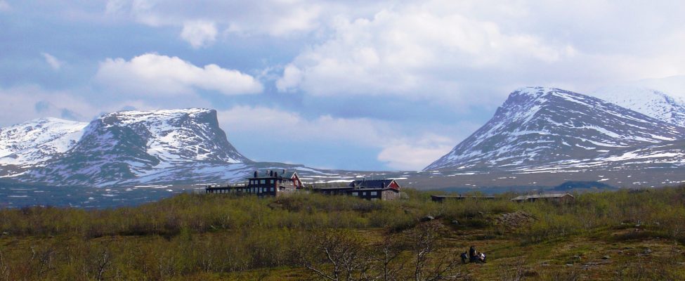
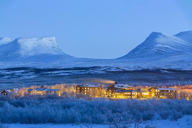
Location

The station is located about 200 km north of the Arctic Circle and approximately 385 m a.s.l., on the south shore of the lake Torne&shy;tr&auml;sk. It is situated in a 46-hectare nature reserve bordering the Abisko National Park, which covers 75 km2. The station is located in birch forest and the nearby area offers a great variety in topo&shy;graphy, geomorphology, geology, and climate, as well as flora and fauna. The highest mountain in the area reaches 1991 m a.s.l.

Climate data

Grey colours are WMO Climate Normals including maximum and minimum values. Blue colours are individual years.

Export to PDF

Climate data for the stations where extracted via Copernicus Climate Data Store, from the global gridded reanalysis product:
ERA5 monthly averaged data on single levels from 1940 to present. Description and source code: Roemer J.K. 2023. https://doi.org/10.5281/zenodo.10214922 Data Source: Hersbach et al. 2023. Copernicus Climate Change Service (C3S) Climate Data Store (CDS), https://doi.org/10.24381/cds.f17050d7

Biodiversity and natural environment

The average annual temperature is approximately 0&deg;C. Annual precipitation for the lake varies greatly over an east west gradient with 1000 mm in the west to 400 mm in the east. Mean annual temperature and the length of the growing season have been increasing over the last decades. The vegetation is extremely varied, ranging from the simple communities that follow retreating glaciers to more complex mountain birch forest ecosystems. About 40% of the surroundings are above the treeline. The area is sparsely populated and land use is minimal being dominated by reindeer husbandry, hunting, fishing, tourism, and research.

History and facilities

The Abisko Scientific Research Station was established in 1913. The station can host almost 100 visitors. Accommodation is available in 28 double rooms, seven 4-bed-rooms and four family apartments. In addition, there are also laboratories, offices, workshops and lecture theatres. Meals are either prepared by the visiting scientists themselves in one of the self-catering kitchens available at the station or, during the tourist season, obtainable at tourist hotels and guest houses within 15 minutes walk. In the nearby village Abisko there is a well equipped grocery store.

General research and databases

Research focuses on plant ecology, geomorphology, and meteorology. The main objectives of the ecological studies are the dynamics of plant populations, identification of the controlling factors at species latitudinal and altitudinal limits, understanding of ecosystem structure and function, and prediction of impacts of global environmental change. The meteorological projects deal with recent Climate Change in the region and local variations in the microclimate. The geomorphology research focuses on the mass-wasting of mountains and sediment transport. Existing databases includes bibliography of publications arising from research at the station, climate records, biological, and physical parameters modelling.

Link to data: https://dataportal.eu-interact.org/stations

Station Monitoring

Human dimension

The nearest settlement is the village Abisko which lies about 1&nbsp;km from the station. The main occupations of the approximately 180 inhabitants are within tourism, transports, and trade. In Abisko there is also both a kindergarden and a school up to the ninth grade. There are a number of tourist hotels in the area, providing a base for both summer and winter tourism. The area is also inhabited by the Sami people who use the area for reindeer husbandry.

Access

The Abisko Scientific Research Station is easily accessible by train, car, bus, and airplane. There are direct trains from the Swedish capital Stockholm to Abisko. The closest railway station is situated less than 1 km away. The resarch station is located just along the main road between Kiruna (Sweden) and Narvik (Norway). Both in Kiruna (100 km away) and Narvik (75 km away) there are airports with several daily flight connections to Oslo and Stockholm. During the tourist season there are bus connections from Kiruna airport to Abisko.

Member of: