Address

Station address

(från fältet Station physical address)

Station manager

Manager name

(från fältet Name of station manager, manager contact details)
E-mail: annika.kallen@umu.se

Contact Station

Phone: Station coordinator: Gunhild Rosqvist ,Tel: Tarfala 072-715 50 39 Stockholm U +46(0)8-164983

(från fältet Station name and website)
E-mail: annika.kallen@umu.se

www.tarfala.su.se

Station Features

Opening year: 1946 Status: Open
  • Type of station: Station
  • Operational period: March-April, June-September
  • Name of station owner: Stockholm University
  • Type of owner: Government
  • Name of managing institution: Department of Physical Geography
  • Managing Institution Country: Switzerland
  • Station owner country: Austria
  • Partner institution: Yes
  • Partner institution name: Ett partnernamn
  • Station latitude: 67,91102058
  • Station longitude: 18,61079381
  • Country (station location): Sweden
  • Altitude of station: 1130 m a.s.l
  • Min. altitude within study area: 0 m a.s.l
  • Max. altitude within study area: 2097 m a.s.l
  • Nearest town/settlement: Nikkaluokta (30 inhabitants)
  • Distance to nearest town/settlement: 27 km
  • Maps available at station: Maps: Tarfala valley (1:20 000) , Glacier maps (1:10 000) ; aerial image; satellite image; Google Earth
  • Type of surface facility is built on: Soft substrate
  • Climate zone: Sub-Arctic
  • Period of measurements for climate data below: 1965-2011
  • Mean temperature in February: 0 °C
  • Mean temperature in July: 0 °C
  • Precipitation type: Snow, Rain, Hail
  • Snow free period (month to month): june to august
  • Sea ice break up: April, May, June, July, August, September, October, November, December
  • Lake ice break up: September
  • River ice break up: July, October, December
  • Dominant wind direction: South
  • Mean annual wind speed: 3 m/s
  • Maximum wind speed (absolute): 81 m/s
  • Landscape features Mountains
  • Permafrost zone Discontinuous, Sporadic
  • Snow and ice on land Glaciers, Permanent snow patches
  • Vegetation zone Shrub tundra, Peatlands, Peatlands/mires, Deciduous forest
  • Wildlife Rodents
  • Human use Animal husbandry

Facilities

  • Area under roof: 50 m²
  • Max. number of visitors at a time : 20
  • Showers: No
  • Laundry facilities: No
  • Power supply - period: 8 AM to 9 AM
  • Power supply - plug type E, F, G, H, I, J, L, M
  • Power sources at station Water, Geothermal, Biofuel
  • Conference room capacity: 0
  • Means of transportation to/from station Snowmobile, Chartered plane/helicopter, Other
  • Air transport landing facilities at station Airstrip, Helipad
  • Airstrip (Length × Width) : 20 x 90
  • Airstrip surface : Snow/Ice
  • Water landing facilities None, Pontoon/float bridge

Science

  • Transnational Access: No
  • Remote Access: No
  • INTERACT Virtual Access: No
  • Permitting issues categories
    • Permits required for access to the station
    • Permits required for studies
  • Partner institutions (involved in the operation of the station)
    • Partner institution
  • Climate
    • Snow
    • Rain
    • Hail
  • Housing and accomodation
    • Showers
    • Laundry facilities
    • A
    • B
    • C
    • D
    • E
    • F
    • G
    • H
    • I
    • J
    • K
    • L
    • M
    • N
    • O
    • Municipal grid
    • Diesel/oil/gas
    • Wood
    • Solar
    • Wind
    • Water
    • Geothermal
    • Biofuel
    • Other
  • Logistics
    • Electrical and IT technologies
    • Mechanical
    • Metal
    • Wood
    • Plexiglas
    • Other
    • Walk
    • None
    • Tracked vehicle
    • Truck
    • SUV (4x4)
    • Car
    • ATV
    • Zodiac
    • Snowmobile
    • Open boat/Dhinghy
    • Closed boat
    • Bicycles
    • Amphibie vehicle
    • Ski
    • Other
    • Snow shoes
    • KickSledges
    • Other
    • Ski
    • Snowmobile
    • Boat
    • Car
    • Tracked vehicle
    • Truck
    • SUV (4x4)
    • Bus
    • Train
    • Airstrip
    • Scheduled flight
    • Chartered plane/helicopter
    • Helipad
    • Other
    • None
    • Harbour/port
    • Warf/pier
    • Pontoon/float bridge
    • Barges
    • Beach
  • Aircraft landing facilities
    • Helipad
  • Features in the facility area
    • Permanent snowpatches
    • Mountain
    • Valley
    • Lake
    • River
    • Shoreline
    • Tree line
    • Polar deserts/semi-deserts
    • Shrub tundra
    • Gramminoid tundra
    • Forest tundra
    • Peatlands
    • Wetlands
    • Palsa mires
    • Deciduous forest
    • Evergreen forest
    • Human settlements or resource use in the area
    • Arable land
    • Other
  • Main science disciplines
    • Astronomy
    • Atmospheric sciences
    • Cryology
    • Geology
    • Hydrology
    • Limnic biology
    • Marine biology
    • Terrestrial biology
    • Human biology
    • Anthropology
    • Archaeology
    • Sociology
    • Climate change
    • Environmental science (incl. pollution)
    • Oceanography
    • Agriculture
    • Animal husbandry
    • Fisheries
    • Forestry
    • Hunting
    • Tourism
  • Workshop facilities
    • Metal workshop
    • Wood workshop
    • Plexiglas workshop
    • Staff available to assist with constructions
  • Communication
    • Telephone
    • Satellite phone
    • VHF
    • E-mail
    • Internet
    • Computer
    • Printer
    • Scanner
    • Fax
  • Landscape and environment
    • Mountains
    • Nunataks
    • Volcano/crater
    • Lava fields
    • Plateaus
    • Moraines
    • Valleys
    • Homothermic Springs
    • Lake
    • Thermokarst lake
    • River
    • Delta/estuarie
    • Fjord
    • Continuous
    • Sea
    • Discontinuous
    • Beach
    • Sporadic
    • Rocky shores
    • Pingos/ice lenses
    • Sea cliffs
    • Other (text)
    • Palsa mires
    • Ice Caps
    • None
    • Glaciers
    • Permanent snow patches
    • None
    • Tree line
    • Polar desert/Semi-desert
    • Gramminoid tundra
    • Shrub tundra
    • Forest tundra
    • Wetlands
    • Peatlands/mires
    • Salt marshes/lagoons
    • Heath
    • Grassland
    • Deciduous forest
    • Terrestrial carnivores
    • Evergreen forest
    • Alpine heath
    • Ungulates
    • Hares
    • Other (text)
    • Rodents
    • Bird colonies
    • Polar bear
    • Whales
    • Seals
    • Fish
    • Settlement
    • Fishing
    • Hunting
    • Forestry
    • Agriculture
    • Tourism
    • Animal husbandry
    • Leisure activities
  • Meteorology
    • Air temperature
    • Air humidity
    • Air pressure
    • Wind velocity
    • Wind direction
    • Precipitation
  • Geology/Geomorphology
    • Quaternary geology
    • Sedimentology
    • Bedrock geology
    • Erosion
  • Pollution
    • In air
    • In water
    • In soil
    • In snow/ice
    • Contaminants in species
  • Snow characteristics
    • Snow depth
    • Snow cover
    • Snow density
    • Snow temperature
  • Mass balace
    • Mass balance
    • Snow water equivalent
    • Snowcover stratigraphy
    • Equilibrium Line Altitude
    • Duration of snow cover
    • Calving flux
  • Climate
    • Climate measurements
    • Energy balance
  • Pollution
    • Pollution measurements in vegetation
    • Pollution measurements in water
    • Pollution measurements in mammals (body burdens, biomarkers)
    • Pollution measurements in birds (body burdens, biomarkers on both adults and offspring e.g. egg shell thinning, macro plastic in nests/in body)
  • Diseases
    • Mammals
    • Birds
    • Fish
    • Vegetation
    • Other
  • Energy balance and radiation
    • Energy balance
    • Short wave incoming
    • Short wave outgoing
    • Long wave incoming
    • Long wave outgoing
    • Net radiation
    • UV-B
    • Multi-spectral
    • Cloud cover/hours of sunshine
  • Parasites
    • Mammals
    • Birds
    • Fish
    • Vegetation
    • Other

Station name and owner

Tarfala Research Station is run by the Department of Physical Geography, Stockholm University, Sweden.<br /><br />(fr&aring;n f&auml;ltet Station name and owner)

Location

Tarfala Research Station is located at 1130 m a.s.l. in the high-alpine Kebnekaise Mountains, northern Sweden. The catchment reaches from 700 to 2100 m a.s.l. and includes several small glaciers of which Storglaciären is extensively studied. The nearest settlement is the Sami village Nikkaluokta, 25 km southeast of the station. There is a mountain tourist station 7 km, and a tourist hut 1 km from Tarfala.

Climate data

Grey colours are WMO Climate Normals including maximum and minimum values. Blue colours are individual years.

Export to PDF

Climate data for the stations where extracted via Copernicus Climate Data Store, from the global gridded reanalysis product:
ERA5 monthly averaged data on single levels from 1940 to present. Description and source code: Roemer J.K. 2023. https://doi.org/10.5281/zenodo.10214922 Data Source: Hersbach et al. 2023. Copernicus Climate Change Service (C3S) Climate Data Store (CDS), https://doi.org/10.24381/cds.f17050d7

Biodiversity and natural environment

Tarfala Research Station is situated in a rapidly changing environment, which offers good opportunities for a variety of bio-geochemical studies. The Storglaciären is one of the best studied glaciers in the World. The long mass-balance record shows how the glacier responds to seasonal climate variability. The retreat of other local glaciers since the early 1900s is also well documented. Permafrost in the catchment is patchy in the lower parts of the valleys but is continuous at higher altitudes. The vegetation ranges from high-alpine flora to mountain birch forest at the tree-line. Wildlife in the area includes reindeer, moose, brown bear, wolverine, fox, hare, stoat, lemmings, and ptarmigan.

History and facilities

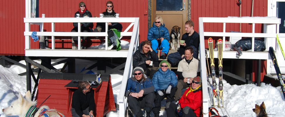
The measurements of mass balance on Storglaci&auml;ren started in the spring of 1946. At that time the scientists used a simple tourist hut as base-camp. In the 1950s, a couple of buildings were built on the present location of the station. The facility could welcome the first students and international scientists in the early 1960s. Today, Tarfala Research Station is a modern facility offering research and education opportunities in a unique subarctic high-alpine setting. Tarfala has c. 25 beds for guests. Rooms with two to four beds are located in houses with running water and dry toilets. Included in the per diem price is breakfast, packed lunch, and dinner. There are no shops in the vicinity. Tarfala Research Station has a modern lecture hall and a well equipped workshop. Internet access via GSM antenna is provided.

General research and databases

Research at Tarfala Research Station focuses on the coupling between climate and glaciers, glacier dynamics, glacial hydrology, geomorphology, mountain meteorology, permafrost, vegetation development, and ecosystem changes, as well as biogeochemistry in ice, snow, water and soil. Tarfala Research Station has its own program for monitoring climate effects on the subarctic environment including glacier mass balance, mountain meteorology, glacial hydrology, snow-chemistry, permafrost, and ecosystem change. The data gives scientists unique and detailed information on the short- and long-term effects of Climate Change and is freely accessible.

Station Monitoring

Human dimension

The nearest village is Nikkaluokta, inhabited by c. 30, mainly Sami people.

Access

Tarfala is located c. 7 km from the Kebnekaise tourist station from where hiking and skiing to the station is possible. Local transport can be arranged from the nearest village, Nikkaluokta (25 km) to Tarfala by snowmobile in winter and by helicopter in summer. Nikkaluokta is located 60 km west of Kiruna, which can be reached by plane or train from Stockholm.

Member of: